|
Fred Henstridge Photography |
|
Creativity through the Pursuit of Excellence. Delivering Quality Products and Services at Competitive Prices. |

|
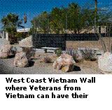
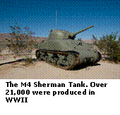
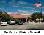
How many times have you driven from Los Angeles to Phoenix on Interstate 10? Once you pass through Indio and are cruising along at 70 MPH (or faster), you probably have thoughts of how soon you will reach Blythe and the Arizona border. The desert landscape is stark and desolate along this stretch of highway. There aren’t many billboards and no Burma Shave signs to distract you and the thermometer can reach over 120 degrees in the summer months. There is little more than a two-lane stretch of pavement ahead of you surrounded by drifting sand, sagebrush and Purple Mountains. You probably didn’t notice an off ramp for Chiriaco Summit Road and an informational sign for the General George Patton Memorial Museum. On the north side of the highway, you might have noticed a Chevron sign if you were getting low on fuel. There is no way to know that this bleak desert was once the home of the largest military training site in World War II, The Desert Training Center. This area is also home to one of the greatest engineering projects in the United States – The Colorado River Aqueduct. One of the lesser-known gems in Southern California is the General Patton Memorial Museum (GPMM). This Tank and Armor Museum is located at Chiriaco Summit on Interstate 10 about 30 miles East of Indio, California and is well worth a visit. The GPMM was established (in association with the Bureau of Land Management) to honor the late General George S. Patton and the thousands of men who served with him at the Desert Training Center and in the North Africa campaigns of WWII. The GPMM is near the entrance to Camp Young, command post for the Desert Training Center (DTC), also known as the California-Arizona Maneuver Area or CAMA, which was established in late March, 1942 (at the beginning of WWII). Then Major General George S. Patton established the DTC and was the first Commanding General of Camp Young and the Desert Training Center. The Desert Training Center was established to prepare Patton's First Army Corp for combat operations in North Africa. There were 11 camps in the Desert Training Center. In addition to Camp Young (Major General George S. Patton's headquarters as Commanding General of the Desert Training Center) were Camp Coxcomb, Camp Iron Mountain, Camp Granite, Camp Essex, Camp Ibis, Camp Hyder, Camp Horn, Camp Laguna, Camp Pilot Knob and Camp Bouse. These camps were scattered about the massive base, which was the largest army base in the world during WWII. It was 350 miles wide and 250 miles deep, covering some 87,500 square miles (56,000,000.acres) The Desert Training Center was disestablished on April 30, 1944. At it's height, in July 1943, there were 10,966 officers, 514 flight personnel, 604 nurses and hospital attendants, and 179, 536 enlisted personnel assigned to the DTC for a total of 191,620 personnel. Today armor training is carried out at the National Training Center at Fort Irwin, California. The museum site was donated by Joseph Chiriaco, one of the first area residents General Patton met when he arrived to set up the center. Chiriaco, a native of Alabama, came West in 1927 to see Alabama play Stanford in the Rose Bowl and never returned to his home state. After serving as a Land Surveyor with the Los Angeles Department of Water and Power (LADWP) in 1933, he gave up his position with LADWP and purchased a parcel of land based on rumors that a new paved road would be built connecting Indio with Phoenix. On August 15, 1933, Joe and his soon to be bride Ruth, opened his gas station and general store at the Summit. He had one dollar in his cigar box till and that dollar remains at the Summit today. In 1945, with the assistance of the Bureau of Land Management (BLM), Joe and Ruth established a memorial to General George S. Patton and the Desert Training Center. Joe and Ruth passed away within months of each other in the spring of 1996.Today the café is still owned and operated by the Chiriaco family. Kathy and I stopped at the Chiriaco Summit Café for a light lunch prior to visiting the Museum We found the interior of the café to be attractive and clean. The food and service was good and the rest rooms were clean. Prices were completive with the franchise coffee shops. Exhibits display memorabilia from the life and career of General Patton. The exhibit halls include the many and varied aspects of military life with emphasis on the Desert Training Center and soldiers of World War 2. There is a huge relief map of Southern California that is worth the price of admission alone. The map weighs almost 5 tons and is so large that Mt. San Jacinto is almost a foot high. Click Here to view a gallery of photos from my visit to the Museum.
|
|
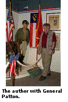
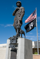
General George S. Patton standing with his dog at the entrance to the General Patton Memorial Museum. |
|
Off The Beaten Path in California |
|
Vol.1, No. 3, Oct 15, 2008 |
|
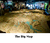
One of the more fascinating items in the GPMM was the “Big Map”. When I say “Big Map”, I mean a really big map! This relief map weighs almost 5 tons and covers most of the museum’s entrance hall. As a surveyor and geodesist, this map was of special interest to me. The Map, donated by the Metropolitan Water District of Southern California (MWD), is a 5-ton topographical wonder depicting in exquisite detail 50,000 square miles around the Colorado River. It also pinpoints the 11 divisional training camps-in Arizona, California, and Nevada used by the DTC/CAMA. These bases trained the men and tested equipment for combat in the North African campaign. The Big Map was constructed for the Los Angeles Department of Water and Power (LADWP) in 1927 to plot the route of the 242-mile long Colorado River Aqueduct. LADWP and contractor survey teams braved the harsh heat of the California, Nevada and Arizona deserts for five years to gather the topographic information needed to determine the best route for the Aqueduct. These surveyors and civil engineers labored with Theodolites, Transits, Spirit Levels, Altimeters, Stadia Boards, and Plane Tables to determine precise positions, set leveling bench marks and gather the topographic data to produce a very accurate relief map. Most of the precise geodetic positions were determined by triangulation, which was done during the nighttime hours. This was done not only to beat the heat, but also to counteract the effects of dessert haze and heat shimmer that would reduce the effective sight distance and cause errors in sighting the theodolite. These heroic surveyors did not have the modern tools of Global Positions System (GPS) and Satellite Mapping. In 1927, the use of Topographic Mapping from aerial photography (Photogrammetry) was still in its infancy in the United States. Once the necessary field data had been gathered by the surveyor’s, twelve expert draftsmen labored for 10 months to construct the 250,000 pieces of fiberboard that make up the map. The map is designed to come apart like a giant jigsaw puzzle. The Big Map was transported to Washington, D.C., during the Congressional hearings prior to passage of the Boulder Canyon Act in 1928. This act paved the way for the creation of the Metropolitan Water District of Southern California (MWD). The Map was donated to the Patton Museum in 1988. As I was standing looking at this Map, I could not help but think of all the professionals who bared the desert heat, rough terrain, and rattlesnakes and labored so diligently to produce this comprehensive and accurate topographic relief map. The map has a horizontal scale of 5,000 feet to the inch (1: 60000) and a vertical scale of 800 feet to the inch (1: 9600). This translates to Mount San Jacinto standing 13½ inches above the table. The straight-line distance, on the Map, from Hoover Dam for Los Angeles (253 miles) is 22 feet. Wow, that’s a really big map! Click Here for more views of the Big Map and the Museum. |
|
The Big Map |
|
At it's height, in July 1943, there were 10,966 officers, 514 flight personnel, 604 nurses and hospital attendants, and 179, 536 enlisted personnel assigned to the DTC for a total of 191,620 personnel. |

|
Control Click on any photo for a larger view. |