
|
Vol.2, No. 2, Feb. 2009 |
|
On February 20, 2009 Kathy and I decided to take a road trip to explore historic Route 66 in California. After our visit to the California Route 66 Museum in Victorville, (see Newsletter Vol. 2, No.1) where we obtained some good guide books and maps, we decided to go all the way to the Arizona border. We left our home at 6:30 am and reached the Colorado River at 3:30 pm. The following details our trip and the stops we made along the way. Each stop indicates a Post Mile (P.M.) that shows the mileage from the “D” Street off ramp on the I-15 in Victorville. I hope you enjoy our account of the trip. |

|
If you are having problems viewing this page or the graphics please Click Here or to visit our Blog Click Here. To view my Galleries of Geo-referenced photos from around the world Click Here. To view additional galleries Click Here. |
|
To remove your name from our mailing list, please click here. Questions or comments? Email us at fhenstridge@henstridgephotography.com or call 951-679-3530 To view as a Web Page Click Here. Please visit our Web Site at http://henstridgephotography.com. © 2009 Fred Henstridge Photography All Photos, Images, Graphics and Text are the copyright of Fred Henstridge Photography. All Rights are Reserved. |

|
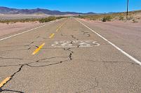
Looking easterly along old Route 66 near Amboy |

|
BARSTOW – P.M. 36 |
|
Barstow is the largest city you will encounter on your Route 66 road trip. With a population of 21,000 the city gets its name from the owner of the Santa Fe Railway, William Barstow Strong. Barstow started getting settled in the late 1840s in the Mormon Corridor. Barstow's roots also lay in the rich mining history of the Mojave Desert. Because of the miners coming to Calico and Daggett following the discovery of silver in the 1860s, railroads were constructed to transport goods and people. The Southern Pacific built a line from Mojave, California through Barstow to Needles in 1883. In 1884, by way of a compromise, ownership of the line from Needles to Mojave was transferred to the Santa Fe Railroad.
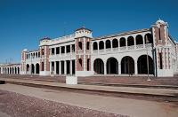
One of the main attractions in Barstow is the Santa Fe Depot and former Harvey House (Also known as The Casa Del Desierto). The depot was constructed in 1911 and has been totally restored. The grounds of the depot also contain a Railway Museum with exhibits of the various locomotives. The City of Barstow obtained the station in 1990 and moved some city offices into the building. The Barstow Area Chamber of Commerce operates out of "Barstow Harvey House". Other tenants are the Western America Railroad Museum, which can be found on the east side, and the Barstow Route 66 "Mother Road" Museum with its entrance on the north side. The museum is opened on Fridays, Saturdays and Sundays from 11 AM to 4 PM.
To reach the Depot you will have to make a slight diversion off of Historic Route 66 by turning left (North) onto North 1st Street and then crossing over the BNSF overpass. The Depot is on the right. You can’t miss it. |
|
DAGGETT – P.M. 45 |
|
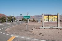
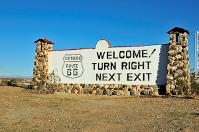
Continue easterly along Historic Route 66. As there is no longer any official designation for U.S. 66 the road is shown on maps, street signs and historic (those little brown and white signs) shields as either the National Trails Highway or Historic Route 66. For the remainder of this newsletter these terms will be used synonymously. After leaving Barstow you will travel easterly along Main Street and then cross under I-40, in the direction of Nebo, where Route 66 is now on the North side of I-40. You will encounter this situation several times on your eastward journey as the designers of I-40 kept moving its alignment either North or South of Route 66. At Post Mile 45 of our road trip you will come to the intersection of Route 66 and Daggett-Yermo Road. There is a big Welcome to Daggett sign on the Northeast corner, you can’t miss it. This is also the route to the Calico Ghost Town.
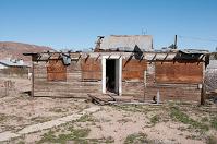
The town was originally founded in the 1880s just after the discovery of silver in area mines. In 1882, the Southern Pacific Railroad from Mojave was being completed in the area and it was thought that a good name for the town would be Calico Junction. But this name would be too confusing since it was right next to Calico, where the silver was uncovered. It was decided to name the city after then Lieutenant Governor of California, John Daggett in 1883. For two years, it was the terminal of the twenty-mule team run from Death Valley, but after one of their swampers, William Pitt was lynched, the Pacific Borax Company made the terminal in Mojave. Not only did silver define Daggett's history, but borax was also important to the city's economy. This borax was being mined, around the turn of the century, out of the Calico Hills nearby. This operation required many more laborers to come to the city to help. The Borate and Daggett Railroad was built to haul borax ore from the mines up in the hills down to Daggett. In 2003 Daggett had a recorded population of 1,000.
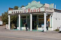
Today Daggett is not much of a town. One of the few remaining businesses dating back to the heyday of the Mother Road is the Desert Market, located on Santa Fe Street about 0.2 miles East of Daggett-Yermo Road. Many of the houses and businesses in this once thriving mining town are merely abandoned ruins today. The two largest industries in Daggett today are the Daggett-Barstow Airport and a defunct solar power plant. The plant used mirror-like heliostats to aim sunlight at a collecting sphere, through which oil flowed. The large quantity of sunlight reflecting on the sphere superheated the oil, which was then used to create steam for power generation. During calibration of the power plant's thousands of heliostats, a ball of glowing light could be seen in the nearby area. This ball was caused by the heliostats reflecting sunlight onto a specific point. As the intensity of the light increases, it tends to reflect off dust in the desert air. This phenomenon was sometimes seen by passersby on the nearby interstates 40 and 15. Perhaps the residents should change the name of Daggett to Goreville. |
|
STATE AGRICULTURAL INSPECTION STATION – P.M. 50 |
|
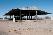
The nest stop on our drive eastward is the abandoned California Agricultural Inspection Station. These fruit and bug inspection station were started in the late 1920 to keep unwanted insects, fruit infestations and Oakies out of the Golden State. This station was built in 1953 to replace the wooden structure constructed in 1930. The original wooden structure was used in the filming of the Grapes of Wrath. It was used until 1967 when the present freeway inspection station was opened on I-40 near Needles. Now we can catch them sooner.
This inspection station has some significant historical significance to me. In 1961 when my bride of one year and I were relocating to California from Ohio with all our earthly belongings packed into a 4x6 U-Haul trailer being towed by a 1961 Dodge we came through this station on a cold February night. The inspector sensing we were smuggling illegal Ohio contraband asked us to open the rear doors of the trailer. I was hesitant to do so as I feared that after five days on the road the items inside would not fare well once the doors were opened. He insisted, so unlocked the two locks I had securing our goods. As I began to open the doors all of the pots, pans and other items in the rear of the trailer began to tumble out. He immediately pushed the doors closed and bade us to be on our way. Welcome to California!
I made a thorough inspection of the site, but could find no pots or pans, only old tires and other miscellaneous desert debris. |
|
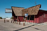
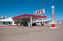
THE BAGDAD CAFÉ – P.M. 57 |
|
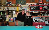
Just east of Newberry Road sits the famous Bagdad Café. When I say famous I am not kidding. Made famous by the movie of the same name the Bagdad Café attracts visitors from all over the world. According to the staff, we spoke with, about 75% of these international visitors come from France. Wow, just think trading escargots and truffles for a buffalo burger. Carol-Lynn, the manager on duty told me that the French say, “It’s the Eiffel Tower and then the Bagdad Café”. As we were signing the guest book I noticed that this was book number 25 and the book had 500 pages. There were an average of 7 signatures per page, so by my count, if I do the math correctly, that’s about 87,500 signatures.
The original name was the Sidewinder Café before the movie Bagdad Café was filmed there in 1987. Believe me when I say when you walk through the door you think you are entering the movie set. Nothing has changed. The staff on duty while Kathy and I were visiting were extremely friendly and Carol-Lynn even suggested she take our photo standing behind the counter. If you have never seen this film, by all means rent the DVD and you will laugh yourself silly, especially if you have ever been to Bavaria.
The Bagdad Café complex consists of the café, a condemned motel, another condemned building, some miscellaneous outbuildings and the Airstream travel caravan that was used in the film.
We were told that there are two more films in the planning stage that will use the Bagdad Café. One is a horror flick that will utilize the motel and another is to memorialize the life of the owner Andrea Pruett. When you make that Route 66 road trip allow enough time to visit the Bagdad Café, better yet plan for your lunch there. You will never forget it. |
|
LUDLOW – P.M. 89 |
|
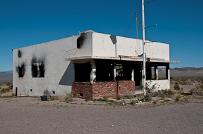
Ludlow was a small town, with a population of about 10 residents, in the Mojave Desert of San Bernardino County, California, United States. The town started as a water stop for the Atlantic and Pacific Railroad in 1883. Ore was found in the nearby hills, leading to a boom. By the 1940s, mining had ceased and the town was left with only the tourist traffic from Route 66. When Interstate 40 was built, there was little business and the residents departed, leaving empty buildings that still stand beside old Route 66. Nothing remains of the Ludlow Café, Garage and Service Station.
The town was named for William B. Ludlow, master repairman for the Central Pacific Railway. Water was hauled to Ludlow by tank cars from Newberry springs. Today nothing remains of Ludlow. The café was burned out and the garage, service station and houses are all abandoned. We did however, eat our lunch under the canopy of the abandoned service station. An earthquake with a magnitude of 5.1 on the Richter scale struck the Mojave Desert at Ludlow near Interstate 40 on December 6th, 2008.
A note of caution! After leaving the Bagdad Café I strongly urge that you double back along Route 66 for 3 miles to join I-40 at Quarry Road and take I-40 to the Crucero Road off ramp at Ludlow. There you will turn right at the bottom of the ramp and pick up National Trails Highway again. There is a Chevron station there if you are in need of fuel or refreshments. The Ludlow Café is 0.3 miles east of Crucero Road. The reason for this deviation is that the section of Route 66 between the Bagdad Café and Ludlow is really rough and it will wrack havoc with your suspension system. There is really nothing to see along this stretch and you will be in full sight of Route 66 from I-40. |
|
LAVA ROCKS – P.M. 114 |
|
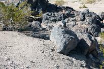
Some good samples of lava rocks can be found at this location. The lava flows are from the Amboy Crater. The entrance to the Amboy Crater is another 1.2 miles east of this location at PM – 115.2. A visit to the crater is well worth your time. I had seen this crater on another visit to the area so I did not include it this road trip. After your side trip you can continue another 1.3 miles east to Amboy Road, where Route 66 again crosses to the north side of I-40 and Roy’s Café. |
|
ROY’S CAFÉ – P.M. – 117 |
|
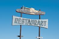
Roy’s Café is the classic gas station and roadside motel of the 50’s. In 1994, according to the Guide to Historic Route 66 in California, Roy’s Café was still operated by the owner (and mayor of Amboy) Buster Burns and had been since 1938. I do not know if Buster Burns is still alive and running the business today, but the complex is in first class condition. It is much sought after by film crews and journalists. This must have been a booming place in the 50’s and 60’s.
On the south side of Route 66, almost directly opposite Roy’s Café is the Amboy Post Office with a statue of a white horse marking the entrance. |
|
THE ROAD RUNNER RETREAT – P.M. 127 |
|
Continuing another 10 miles east on Route 66 will bring you to the ruins of the once famous Road Runner Retreat. Forlorn and abandoned today, this was once one of the highlights of a trip along Route 66 in California. The retreat consisting of a café and service station was once used for a Dodge television commercial in 1988. Oh, for those days of yesteryear, |
|
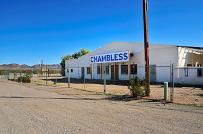
CHAMBLESS – P.M. 128 |
|
Another mile along Route 66 is the Café, Market and Service Station at Cadiz Road. Chambliss is one of the few shady spots along the entire desert route. The building is made from handmade bricks. Now abandoned, the 1930’s era market and gas station was temporarily closed in 1991. Temporary turned to permanent, yet some guide books still show it as an active café and gas station. However, the old tourist cabins were one used to house the migrant workers farming the grape vineyards in Cadiz 3.5 miles southerly on Cadiz Road. In 2005, the population of Chambless was 6 residents and one dog, as posted on a sign entering the town. Right across from the abandoned market is a monument to Route 66. Take time to read the bronze plaque. |
|
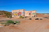
CADIZ SUMMIT- P.M. 132 |
|
At a place called the Cadiz Summit, because it’s at the top a grade near Cadiz, are some abandoned ruins of a service station and tourists cabins. Today they are mere canvases for graffiti artists. The summit tops out at 1,300 feet.
There is not too much more to be seen easterly of the Summit to the Colorado River. In many locations the old Route 66 has either been destroyed or incorporated as a part of I-40. At what was once Essex you can take what is known as the Goffs Road Loop that will take you north of I-40 where you will once again join the Historic Route 66 at Arrowhead Junction where Goffs road meets State Route 95. This route follows one of the alignments of Route 66 and we decided not to follow this route as we wanted to reach the Colorado River in good lighting. Instead we followed National Trails Highway to the Mountain Springs Road interchange (P.M. 163) where we joined I-40 to continue our eastward journey to the Arizona border. |
|
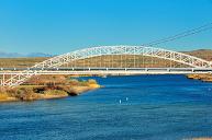
ROUTE 66 BRIDGE OVER THE COLORADO RIVER – P.M. 213 |
|
This marks the end of our trip along the Mother Road in California. If you take I-40 to Park Moabi Road and then turn left (northerly into the park) and follow the signs for the National Old Trails Highway you will cross back under I-40 and the BNSF railway bridge and then come to a dead end where there is a large Route 66 sign that can be seen from I-40. This is a perfect overlook to see the three bridges crossing the Colorado River into Arizona. These bridges are, from left to right (when looking east), the BNSF railway bridge, the I-40 Bridge and the Old Trails Arch Bridge, built in 1916 and now a pipeline bridge. This bridge was featured in the film, Grapes of Wrath. |
|
This ends our Route 66 road trip from Victorville to the Arizona border. The total trip was 213 miles from the “D” street off ramp on the I-15 in Victorville. It was a very rewarding trip and it brought back many memories for Kathy and me. The weather was great and there was only one bad stretch along the old Route 66. Our next venture will be to try to navigate Historic Route 66 in Arizona. Many of the items mentioned in this article have links that will take you to Internet sites where you can obtain additional information or to photographs that I took along the way. There are numerous guide books and maps that you can use for your Route 66 road trip and I recommend that you consider purchasing one at the Route 66 Museum in Victorville prior to your trip. All of my photos were taken with a GPS equipped Nikon D300 so the positions were accurately recoded with the image. For a complete gallery of all the photos I took please Click Here. |
|
Santa Fe Depot and former Harvey House in Barstow |
|
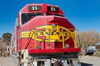
Santa Fe Super Chief Locomotive, Barstow Railway Museum. The Super Chief could make the trip from Chicago to Los Angeles Union Station in 36 hours. |
|
Welcome to Daggett sign at Route 66 and Daggett-Yermo Road |
|
Abandoned dwellings in Daggett |
|
The Desert Market in Daggett, established in 1908 |
|
Former State Agricultural Inspection Station—Daggett |
|
Bagdad Café (formerly the Sidewinder Café. |
|
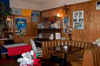
Interior of the Bagdad Cafe |
|
The fire destroyed remains of the Ludlow Café |
|
Looking easterly along Route 66 at Ludlow |
|
Lava rocks by Amboy |
|
Roy’s Café, Amboy |
|
Road Runner Retreat |
|
Chambless Café and Market |
|
Cadiz Summit |
|
Route 66 sign overlooking the Colorado River |
|
Old Trails Arch Bridge |
|
For this edition of the Newsletter I have added links to the geographic positions of where the various photos were taken. In the caption under each photo is a link to the Map View. Clicking this link will take you to my Panoramio Web Site where you see the both the photo and its proper GPS position. If you go to the Panoramio site please select the Route 66 tag to the right of the thumbnail images. Also be sure to visit my Blog and see Entry no. 13 for some technical details pertaining to the photography. I think you will find it interesting. |
|
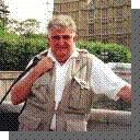
Kathy and me at the Bagdad Cafe |